10 Days Rwenzori Trek To 4 High Peaks Margherita Peak, Speke, Baker, Weismann’s Peak.
The 10 Days to 4 High Peaks of the Rwenzori Mountains: Margherita Peak 5,109m, Mt. Speke 4,890m, Mt. Baker 4,844m, Weismann’s Peak 4,620m at $1590 for hiking cost along with an additional $35 per night for national park entry fees. Generating a total of $1905 for each individual. The hiking fees cover guides, porters, meals, and accommodation during the trek.
Not included: Tips, insurance, personal expenses, accommodation prior to and following the trek, and transfers to and from the starting location.
Detailed 10 Days Rwenzori Trek To 4 Highest Peaks
Day 1: Transfer to Basecamp, briefing, and hike to Sine Camp at 2596m
Begin your journey at Trekkers, situated at 1,450 meters, and ascend to Sine Hut at 2,596 meters, achieving a height gain of 1,146 meters. For those in good shape who wish to continue, you can proceed to Kalalama Camp at 3,134 meters. This route not only offers breathtaking views but also allows for additional time at Mutinda Camp, where you can climb up to Mutinda Lookout at 3,975 meters.
We begin our journey by ascending the valley floor, surrounded by the towering trees of the Afro Montane Forest Zone. This is a gradual ascent filled with numerous birds and an opportunity to spot blue monkeys darting through the trees. Occasionally, visitors might observe groups of 15 to 20 black and white Colobus monkeys as they gracefully navigate the treetops. Rare sightings of the L’Hoest monkey, which are part of the Bukonzo cultural emblems, are protected by the authority of the King or Omusinga. You may also hear wild chimpanzees in the distance. A diverse array of plant species exists, ranging from towering forest trees to bamboo thickets, low shrubs, vibrant flowers, and fungi. Many moss and lichen-covered vines drape from the tall trees, enhancing the captivating beauty of the landscape. Enock’s Falls are located a mere 200 meters from Sine Hut, providing a wonderful chance to create a stunning screensaver for your memories.

At Sine Camp, situated at 2,596 metres, wooden huts are nestled among tall forest trees on a narrow ridge. Here, you can sit and appreciate the stunning beauty of the Afro Montane forest while gazing down at a magnificent waterfall cascading over the rocks far below. Some clients enjoy sitting outside, relishing the warmth of the campfire while engaging in conversation with the guides about the mountains and their community life. Sine lies just beneath the bamboo zone, and the surrounding area is home to a variety of bird species. Enock Falls is located just 150 meters from the camp, surrounded by vibrant green vegetation and cascading vines. Genuinely stunning. Rest at Sine Camp, situated at an elevation of 2,596 meters.
Day 2: Journey to Mutinda Camp 3588m
The trek begins at 8:30 AM, and you quickly find yourself in the Bamboo-Mimulopsis Zone, where the ascent is steep and features numerous high steps. During the wet season, the bamboo zone becomes quite muddy and slippery, resulting in slow progress. Nonetheless, the ambiance and the forest are stunning as you ascend 551 meters in altitude over a distance of 1.8 km to reach Kalalama Camp at 3,147 meters. This location is situated in the Heather-Rapanea Zone, where you can pause for a moment and enjoy a quick cup of tea or coffee before continuing on to Mutinda Camp. The trail winds its way up and over a series of gentle knolls along the ridge, then descends into the valley before ascending once more, crossing several small streams and passing near moss-covered waterfalls along the way. You then ascend gradually alongside a picturesque moss-covered river that cascades over the stones beneath the towering Giant Heather trees, their trunks draped in green moss and adorned with the wispy strands of old man beards (Usnea lichen) hanging from the branches. The path winds and curves as you ascend the steep valley, showcasing a vast array of plants and flowers. This valley stands out, featuring numerous Giant Heather trees that contribute to a stunning ambiance frequently enveloped in mist.
In the afternoon, you might consider ascending to the summit of the Mutinda Lookout (approximately one to two hours up and one hour down). The vistas are breathtaking as you stand on moss-covered rocks at 3,925 meters, overlooking the Rwenzori Mountains and gazing down at Kasese town and Lake George. Clients aiming to reach Margherita or any of the main peaks will find that climbing Mutinda at 3,975 meters serves as an excellent method for acclimatization, thereby minimizing the risk of high altitude sickness.
Rest at Mutinda Camp at an elevation of 3,588 metres
Day 3: Trek to Bugata Camp 4062m
The path to Bugata Camp is quite muddy, especially during the wet season; however, with some finesse, you can navigate by stepping from tussock to tussock to ease your journey. Initially, you traverse the Mutinda valley, navigating through tussock grass and everlasting flowers, dotted with numerous Giant Lobelias. This leads you to a challenging ascent up to the Namusangi Valley (3,840 meters), where sheer waterfalls cascade down, and as you glance back, you are rewarded with stunning views of the Mutinda Peaks. The Namusangi Valley is expansive, featuring numerous elevations as the path ascends consistently to Bugata Camp at 4,100 metres.
Day 4: Trek to Hunwicks Camp 3974m
Journey to Hunwick’s Camp through Bamwanjarra Pass. Upon departing Bugata Camp, you will ascend a ridge before gently descending, followed by a climb to Bamwanjarra Pass at 4,450 meters, where a hut awaits in case of inclement weather. On a clear day, the pass offers stunning views of the three main peaks. The trail winds through the valley, skirting the edges of bogs and dense evergreen vegetation, including moss, giant groundsel, and lobelia. This location may be the finest in the Rwenzori for observing the Malachite Sunbird as it feeds on the abundant lobelia flowers and serves as a recognized breeding site.
Further along, there are some steep sections followed by a steady ascent over a ridge to Hunwick’s Camp, located at the top of a deep valley, offering excellent views of Mt Stanley, Mt Baker, Weismann’s Peak, and McConnell’s Prong.
Day 5: Ascending Mount Baker at 4842m and resting at Hunwick’s Camp at 3974m
A climb of 4.3 kilometers takes approximately 4 to 6 hours to ascend and 2 to 3 hours to descend. Departed at 6:30 AM to ascend Mount Baker Peak, standing at 4,842 meters. The ascent from McConnell’s Camp (Camp 4) to the summit takes three to four hours, while the descent requires about three hours. This climb is steep and rocky, requiring a strong head for heights, especially in sections like the crevice leading down to the glacier, which features a significant drop-off on the side. While steep Mt Baker is regarded as non-technical, it becomes quite slippery on the ice-covered rocks during the snow season (wet season) of April-May and September-October. Therefore, safety ropes will be utilized at all times on the steep sections. Upon reaching the summit, you make your way down a fissure in the rock face to the glacier, followed by a brief 300-meter stroll to the peak.
When the weather is pleasant or the clouds part, the vistas of the prominent peaks of Magherita, Alexandria, Stanley’s plateau, and the glaciers are truly remarkable, showcasing the magnificence of these stunning snowcapped mountains. The view is spectacular! Having taken in this lifetime experience, we make our way back across the glacier, ascend the crack in the rock face, and descend to McConnell’s Camp. Rest at Camp 4.
Day 6: Trek to Margherita Camp at 4485m
Embark on a hike to Margherita camp at 4485 meters, traversing down and across the valley floor to the breathtaking Lake Kitandara, known for its deep waters and lush vegetation, before ascending through Scoot Elliot pass to reach Margherita camp. Breakfast, Lunch, Dinner
Day 7: Summit Margherita Peak at 5109m on Mount Stanley
Rise at 1:30am to enjoy an early breakfast before departing to ascend Mt Stanley at 2:00am. Ascend to Stanley Plateau, where you will traverse the initial glacier before descending to the base of Margherita Peak. The lower section of the glacier is steep and requires low-level technical skills, necessitating the use of ropes and belays.
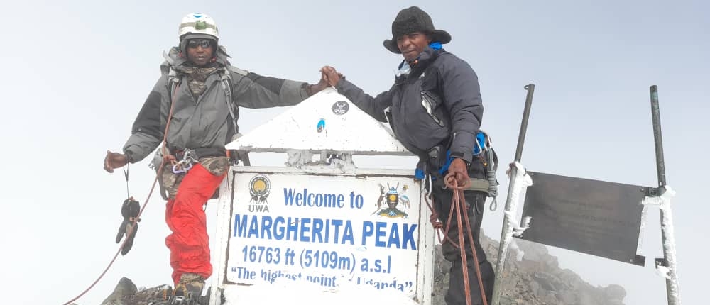
As you approach the summit of the glacier, you will encounter some steep rocky climbs for approximately 60 meters to reach the ridge leading to Margherita Peak at 5,109 meters. Descending the glacier past Irene Lake into Bujuku Valley, you will cross a long bog to reach the base of Mount. Speke, standing at 4,890 meters, where you will set up a rough camp in a small rock shelter.
Day 8: Reach the summit of Vitorrio Emmanuel at 4890m on Mount Speke, then spend the night at Hunwick’s Camp.
Ascend to Mt Speke at 4890 meters, then retrace your steps to traverse the Bujuku Valley. Continue the ascent to Scott Elliot Pass before descending to Hunwick’s Camp at 3974 meters.
Day 9: Ascend Weismann’s Peak at 4620m on Mt. Luigi Di Savoia and descend to Kiharo Camp at 3430 meters.
We begin our day at Hunwicks Camp by ascending a ridge that leads us to McConnell’s Prong, offering stunning views of all three peaks and Scott Elliott’s Pass before we arrive at Oliver’s.
Crossing at 4,505 metres. The distance from Hunwick’s Camp to the summit of Oliver’s Pass is 3km. The path then traverses beneath Weismann’s Peak, leading to the meeting point of the Nyamwamba River. For those who still possess the strength, you can choose to tackle the summit of Weismann’s Peak before continuing on to Kiharo Camp at 3430 meters. Experience an overnight stay at Kiharo Camp, nestled within a deep valley surrounded by towering cliffs and lush vegetation. Breakfast, Lunch, Dinner
Day 10: Return to Base Camp
The distance from Kiharo Camp to the park gate is 12.2 km, followed by an additional 2.8 km down to Trekkers Hostel. It is essential to walk for 5 to 8 hours, so those needing to catch flights back to Kampala or continue with other activities should depart from Kiharo early.
The trail through the Nyamwamba Valley descends gently, offering breathtaking views. The scenery features moss-covered rocks by the river, cascading waterfalls, and deep valleys surrounded by lush forests, making it one of the most remarkable areas in the Rwenzori Mountains. This section of the trail required six years for us to discover a suitable passage and a route that is accessible for tourists. In 1937, the explorer and geologist McConnell attempted to navigate this valley but was unsuccessful and had to retreat in search of an alternative route up the mountain. Today, however, you can experience the breathtaking beauty of this valley. Summary and distribution of certificates.